Climate stress test light, Municipality of Oirschot
In the autumn of 2015, the municipality of Oirschot commissioned a climate stress test light with the support of the Ministry of Infrastructure and the Environment. No full stress test was conducted, but insight was given into the challenges that the municipality faces and recommendations were made for subsequent steps. The stress test light was conducted in the form of a climate change studio: a workshop aimed at gaining insight into the impact of climate change on the living environment in the municipality of Oirschot and the interconnection between the various climate issues, the water system, and spatial planning.
Process
The climate change studio was organised in the following manner:
- During an intake interview, the goal and definition of the studio was discussed, a draft programme was drawn up, as was a list of people and organisations to be invited. Agreements were also reached on the exchange of information.
- The climate change studio itself was held on 16 September 2015.
- On 10 December, the studio was evaluated.
To prepare for the climate change studio, basic maps were created for the three relevant climate themes on which the expected effects of climate change were shown. These maps were discussed during the studio. Information included on the maps was assessed for its completeness and relevance to the municipality. As a summary of the discussions held on the basic maps, a vulnerabilities map was created: at what locations and in what respects is Oirschot vulnerable to climate change?
Results
Following the climate change studio, the vulnerabilities map below was created.
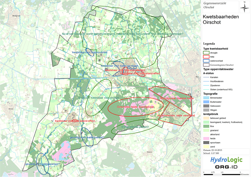
During the climate change studio, we discussed the climate issues. The most important comments and vulnerabilities are:
Knowledge requirement and development
- In the year ahead, the district water board will calculate the impact of pluvial flooding in built-up urban areas from surface water (T=100). The sewerage system is included as input and not integrated into the calculation model.
- In 2015, the municipality developed a pluvial flooding map that showed flooding and the risks of damage due to extreme rainfall. In its policy, the municipality sets out that damage caused by rainwater from public areas will be unacceptable up to a recurrence time of T=100+10%.
- The spatial planning adaptation will be rooted in integral district management programmes. Resources will come from the vGRP 2015-2019 currently in force;
- The district water board recently installed a groundwater measurement network in natural areas. This enables the monitoring of (potential) desiccation.
- Based on all available data from soundings taken and groundwater monitoring pipes, the municipality has gained insight into the possibilities for infiltration (inside and outside the built-up urban area). The data will be linked to a groundwater measurement network (expected to be operational in 2016), so that a clear picture is obtained of the trends in municipal groundwater levels at both the regional and local levels;
- Questions with respect to the national groundwater model: what are the starting points, what input data has been used (e.g., land use as well?);
- Beerze: groundwater and surface water flooding has been reduced, in part due to measures such as the ongoing brook restoration of the Beerze. At Spoordonk, the district water board is restoring the flood defence system;
- Apparent groundwater levels; in heathland areas within the municipality, apparent groundwater levels appear due to loam deposits. Based on experiential knowledge, the municipality knows about these soil types but it does not have a complete and substantiated picture;
- Soil becomes impermeable; the behaviour of the top layer of soil can change due to drought and heavy rainfall. The impact this may have within the municipality is unknown.
Climate change effects
- It has been established that a fall in groundwater occurs least in heathland areas and the most in agricultural areas. The (other) natural areas fall between these two. The pertinent question of “how relevant is this?” depends in part on the target ecosystem. Traditionally, the Kempen is drier and the Meijerij is wetter.
- What consequences do (longer) dry periods and lower groundwater levels have for the “irrigation policy” for agriculture?
- Extreme weather conditions in general and specifically in hot summer periods, extreme rainfall, thunderstorms and storms present increased risks of events occurring.
- Drought and heat present an increased risk of wildfire (heathland) and potentially also for recreational housing.
Read more about the conclusions and recommendations in the document attached to this practical example (Dutch).
Contact person
Dick Bakker
Municipality of Oirschot
+31(0)6-20447233
D.Bakker@oirschot.nl