Climate stress test light, Municipality of Oisterwijk
In the autumn of 2015, the municipality of Oisterwijk commissioned a climate stress test light with the support of the Ministry of Infrastructure and the Environment. No full stress test was conducted, but insight was given into the challenges that the municipality faces and recommendations were made for subsequent steps. The stress test light was conducted in the form of a climate change studio: a workshop aimed at gaining insight into the impact of climate change on the living environment in the municipality of Oisterwijk and the interconnection between the various climate issues, the water system, and spatial planning.
Process
The climate change studio was organised in the following manner:
- During an intake interview, the goal and definition of the studio was discussed, a draft programme was drawn up, as was a list of people and organisations to be invited. Agreements were also reached on the exchange of information.
- The climate change studio itself was held on 12 September 2015.
- On 10 December, the studio was evaluated.
To prepare for the climate change studio, basic maps were created for the three relevant climate themes on which the expected effects of climate change were shown (Appendix B). These maps were discussed during the studio. Information included on the maps was assessed for its completeness and relevance to the municipality. As a summary of the discussions held on the basic maps, a vulnerabilities map was created: at what locations and in what respects is Oisterwijk vulnerable to climate change?
Results
Following the climate change studio, the vulnerabilities map below was created.
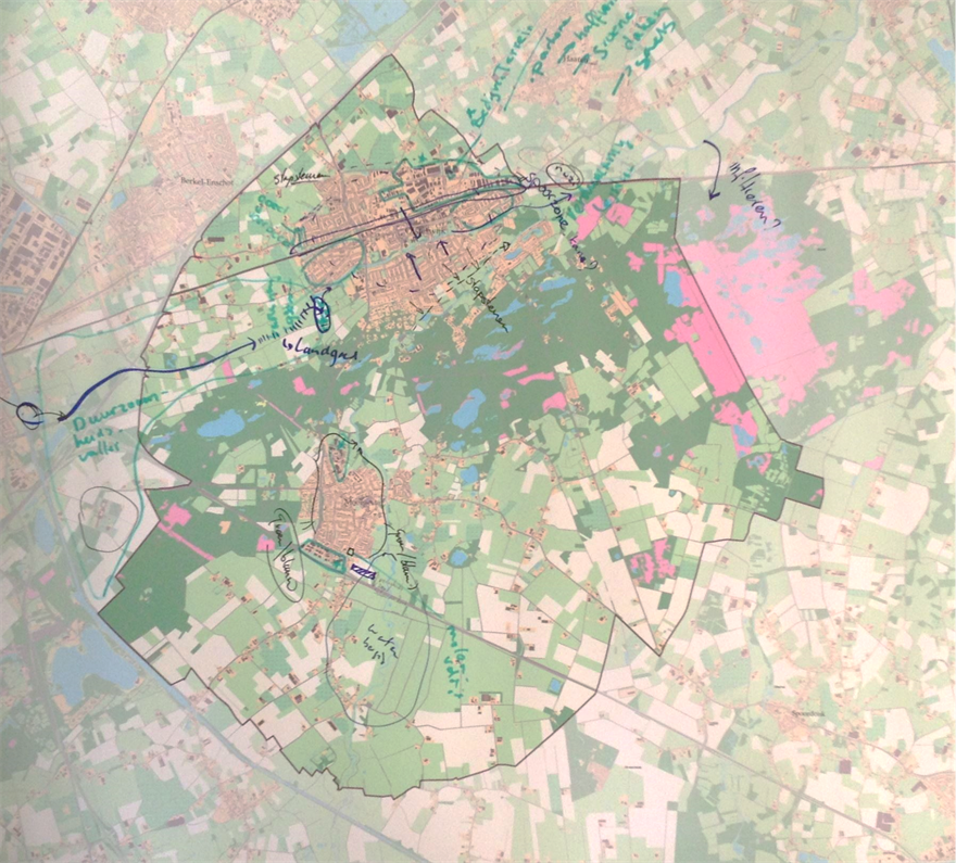
During the climate change studio, the climate themes were discussed. The most important comments and the vulnerabilities are listed below.
Knowledge requirement and development
- We need to explore how pluvial flooding will impact the retirement homes and hospitals, considering the (implicit) fact that these accommodate vulnerable groups of people.
- An inventory and the location of vital, vulnerable infrastructure and buildings are missing.
- A number of additions are indicated on the maps (see adjacent document). With respect to pluvial flooding, it appears that insight is almost entirely based on experiences.
- “Water in the street”: indicated on the map by green circles;
- Groundwater flooding in buildings is only known in one location: “rising groundwater”. Whether or not additional locations are affected by groundwater flooding is not known. In principle, groundwater flooding can be prevented by eliminating crawl spaces in buildings.
- No rise in groundwater has been established or measured in reality. Draining water runs to streams and not to groundwater.
- The tree nursery/maize area has been drained; this area may be vulnerable to pluvial flooding. Besides, the area is dependent on the supply of water for its water provision.
- The extent to which this could become a limitation during longer periods of drought is not clear.
- In general, all “wetlands” are (potentially) vulnerable to a fall in the groundwater level. Has consideration been given to this possible fall in the level of the groundwater?
- The greening of roads should be seen in relation with other policy aspects, such as safety and accessibility. This is a political consideration.
Climate effects
- One mere is dependent on groundwater. The other meres lie on an impermeable or poorly permeable layer of loam. For the correct water quality, these meres depend on lateral flows of groundwater. This local seepage can possibly decrease when the level of groundwater falls.
- Wet heathland is vulnerable to falls in groundwater level (GLG) of 10 to 20cm (or more).
- During droughts, farming depends on irrigation to provide crops with water, depending on whether or not there is a ban on drawing water from surface water and/or groundwater. In the most recent land re-parcelling process, new wells were allowed. The policy of the district water board is to issue no new permits.
- Dried-up and stagnant ponds and watercourses in urban areas produce a stench and dead fish.
- Buildings are not dependent on groundwater. Groundwater flooding is not an issue. The green areas in urban centres are sensitive to dry periods.
- The blue algae problem is not very significant in this region.
- Fire danger: camping sites, not a danger for buildings.
- The heat picture is familiar.
- Green vegetation leads to lower environmental and apparent temperatures;
- Differentiation in districts can be seen;
- In the countryside, it is apparent that tree and flower cultivation is cooler than maize.
- An increase in “hot temperatures” will lead to a greater need for open-space areas. This can increase the burden on natural areas, resulting in parking lots filling up, and also lead to more heat stress (traditionally designed parking lots reinforce the urban heat island effect).
Read further about the conclusions and recommendations in the document attached to this practical example (Dutch).
Contact person
Frans Veeke
Municipality of Oisterwijk
Frans.Veeke@oisterwijk.nl