Climate-Proof Water Level Ordinance for Pernis
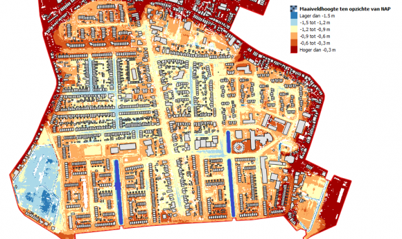
With respect to water management, the village of Pernis is in a rather typical situation, featuring soft soil (peat and clay). As the surface level map below shows, the Pernis soil has subsided over recent decades, which is now causing streets and houses to flood.
Some sort of bathtub has formed which collects water (both water from deeper soil strata and precipitation), without any options for natural drainage. Because of the flooding issues, residents have requested the district water board to lower the surface water level, in order for the soil to dry out. A model study shows that level reduction will not have a positive effect, especially in climate scenarios involving wetter winters, drier summers, and more extreme downpours. Lowering the water level, in combination with drier summers, will cause an even deeper and faster subsidence of the bathtub, as a result of which flooding will increase rather than decrease. A combination of a relatively high surface water level and improved regulation of the groundwater level (levelling off peaks) by means of drainage could potentially offer a solution.
Results
Study conducted
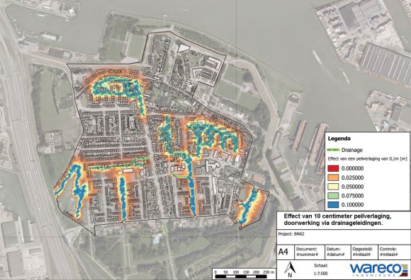
This study has been prompted by the new water level ordinance that will be drawn up. Pernis is currently faced with groundwater flooding. The district water board has been requested to investigate whether a 10 cm level reduction in measuring section 47-3 could be an appropriate measure. Pernis is located in a soft soil area (peat and clay). Thus, changing the water level also carries risks with respect to excessively low groundwater levels (soil subsidence and damage to buildings). For that reason, a specialist study has been conducted into water management in the measurement section in relation to the built-up environment.
There is no reliable database with foundation data on Pernis. The fact is that both steel and pile foundations (wood and concrete) have been used to build houses. In some cases, the different buildings with conflicting interests (groundwater flooding versus drying out) are located at a short distance from one another. The municipal authorities have indicated that many buildings have subsided vis-à-vis the distribution level. In addition, the conspicuously low surface level in some streets is a sign of surface level subsidence. Something that immediately catches the eye during a site visit is that the doorsteps of many front doors are located approx. 20 cm above street level. This may indicate subsidence of the public area vis-à-vis the houses. This is quite common among pile-founded houses. The municipal authorities have also indicated that in some houses the floor level is located slightly below the street level. These relatively low floor levels are caused by subsidence of the (steel-founded) houses, while the streets have meanwhile been raised again.
A model has been drafted for the polder water balance, factoring in precipitation water, seepage from the deeper soil, and seepage from the river. All this water ends up in the shallow soil and needs to find its way to the polder surface water. As there is relatively little surface water, its direct impact on (groundwater) flooding is zero. The model shows that leaky sewage pipes currently play an important role in the discharge of water from the soil to the surface water. The leaking sewerage has a drainage effect. However, the municipal authorities are replacing these leaky pipes.
A climate-proof water level ordinance
One the one hand, steel foundations require a lower groundwater level in order to prevent flooding. On the other, a continuously higher groundwater level is required to prevent further, accelerated soil subsidence and pile rot. In the future, climate change will add to this bottleneck. This issue has a distinct bearing on spatial planning and urban development (urban renewal), because surface level subsidence impacts on the quality of a residential area. Environmental policy and currently the water level ordinance need to cater for the conflicting interests and to contribute to a reduction of these conflicts in the event of climate change. In addition to any constructional measures required to combat flooding, active groundwater level management on both public and private ground may offer a solution. It enables the realisation of a sufficiently high groundwater level in order to reduce soil subsidence and pile rot, while at the same time limiting flooding. The water level ordinance should be geared to the desired groundwater situation. After all, in addition to a discharge channel, the surface water level also serves as the water feed channel for groundwater regulation.
Contact person
Janneke van Gorsel
Waterschap Hollandse Delta
+31(0)88-974 3000
j.vangorsel@wshd.nl