Stedendriehoek region
The Stedendriehoek region is a pioneer in the field of spatial adaptation. It is developing a climate-resilient and water-proof regional plan.
Results
AMBITION – GOALS AND AMBITIONS
Business climate is the topic that unites the region. The determining factors are soil, water, and greenery. The first step in the process involved garnering administrative commitment. Encouraged by the district water board, administrators in the region have set down the ambition of developing a regional vision with water, soil, greenery, and the climate as directive pillars.
ANALYSIS – STRESS TEST LITE
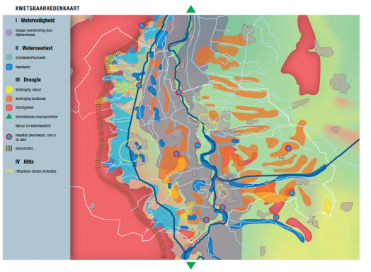
By reference to the maps from the climate impact atlas, the region subsequently commissioned a first indicative summary map of the aspects of pluvial flooding, drought, heat, and flood risks. This map has been discussed in a workshop involving experts from the municipalities and district water boards. This has generated a rough susceptibility map based on local know-how and insight.

Subsequently, the Clico Tool was used to make calculations in order to determine the total additional damage in the event that the region did NOT embark on spatial adaptation. This damage has been estimated at between 100 and 500 million euros, over the period up to 2050.
AMBITION – VIABLE STRATEGIES
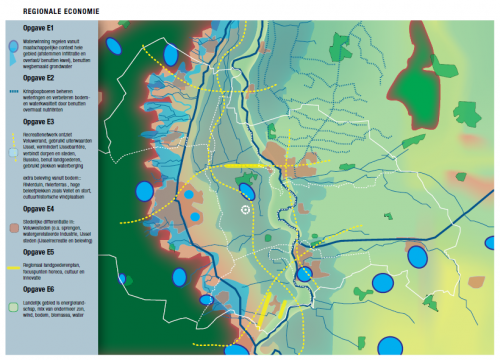
The regional partners then rolled up their sleeves to focus on design. Using guide models and the natural alliance methodology, inspiration maps have been made with ideas on enhancing resilience and the regional economy.
The vision has not yet been elaborated into viable strategies, but it has generated a number of regional taskings relating to resilience and the regional economy.

ACTION – SAFEGUARDING
The ideas have not yet been set down in policy. A rapport (see download) has been submitted to the Physical Domain working group of the Stedendriehoek.
