Tour of Rivierenland
“Finding more room for water.” That was the reason why the Rivierenland district water board responded, along with five municipalities, to the call of the then Ministry of Housing, Spatial Planning and the Environment to initiate the so-called W+R [Water and Spatial Planning] ateliers. The five municipalities – Alblasserdam, West Maas en Waal, Neder Betuwe, Groesbeek, and Geldermalsen – intend to look for practical solutions to water and spatial planning taskings at the local level.
Results
Five ateliers in the various municipalities have generated draft proposals for local spatial planning, combining peak water storage with other forms of use, such as recreation, habitation, and Nature. The atelier working method offers a good instrument for addressing water and spatial planning issues. In the autumn of 2010, the district water board set up a W+R atelier together with another five municipalities.
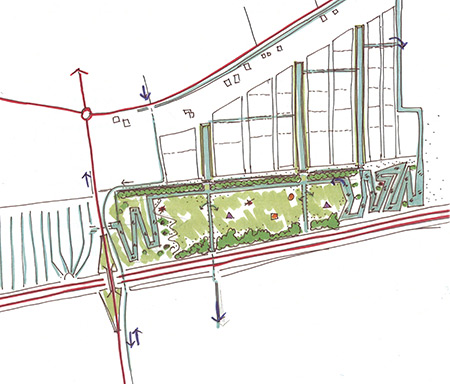
Figure: proposal for a new water structure along the southern outskirts of BenedenLeeuwen
For each of the five ateliers, a working document has been published, reflecting the results in words and pictures. Below is a brief summary.
- “Castles and water belts” is the title of the working document for the atelier in the municipality of Geldermalsen. The document gives an initial impetus to finding more room for water based on an integrated approach, involving, for example, the use of locations of cultural-historical significance and patterns in the planning area.
- “The outskirts are the showpiece of the village” describes the outcomes of the atelier in the municipality of Neder Betuwe for Opheusden and the surrounding area. The collaboration between the atelier participants has provided impetus to interlinking water and spatial planning taskings, with surprising solutions to peak water storage and a “facelift” for the southern entrance to the village.
- The atelier for the municipality of West Maas en Waal (expansion of the Beneden-Leeuwen town centre) was named “Opportunities on the horizon”. It has resulted in a target picture for the manner in which water can be substantiated and given shape in and around the new residential area. It combines the objectives with respect to peak water storage, design of the public space, and recreational use.
- “Between Alblas and A15” describes the results of the atelier for the municipality of Alblasserdam. Interesting leads have been discovered in the area on which the study focused, between the dynamics of the A15 motorway and the peacefulness along the Alblas river. They have been roughly elaborated to combine peak water storage with other forms of use.
- The final atelier “Groesbeek and the Groesbeek brook” describes the necessity of an overall vision for the basin of the brook from which the municipality has taken its name. Such a vision is required in order to be able to attain both the short-term and long-term goals in the fields of water management and spatial development.