Loon op Zand climate workshop
The climate workshop is intended to gain insight into the effects of climate change on the living environment in the municipality of Loon op Zand, and the interconnectivity of the various climate issues, the water system, and spatial planning. The workshop involves a “stress test light”: insight into the tasking with which the parties are faced, and recommendations regarding subsequent steps, based on knowledge and information currently available. In essence, the climate workshops focus on the four themes set out in the climate impact atlas: flood risk management, pluvial flooding, drought, and heat.
Process
The climate workshop was structured as follows:
- During an intake meeting, the participants have exchanged their views regarding the purpose and scope of the workshop. In addition, they have drawn up a draft schedule and a list of individuals and organisations to be invited. They have also set down agreements regarding the exchange of information.
- The actual climate workshop was held on 2 June 2016.
- The workshop was evaluated on 5 July.
In preparation for the climate workshop, basic maps have been drafted for the four relevant climate issues, indicating the climate effects to be expected (see Appendix B to the downloadable document). These maps have been discussed during the workshop. The information contained in the maps has been assessed for completeness and relevance to the municipality. The discussions on the basic maps have been summarised into a vulnerabilities map, indicating the locations at which the municipality of Loon op Zand is vulnerable to climate change, and the issues that may come into play.
Results
The climate workshop has generated the vulnerabilities map below.
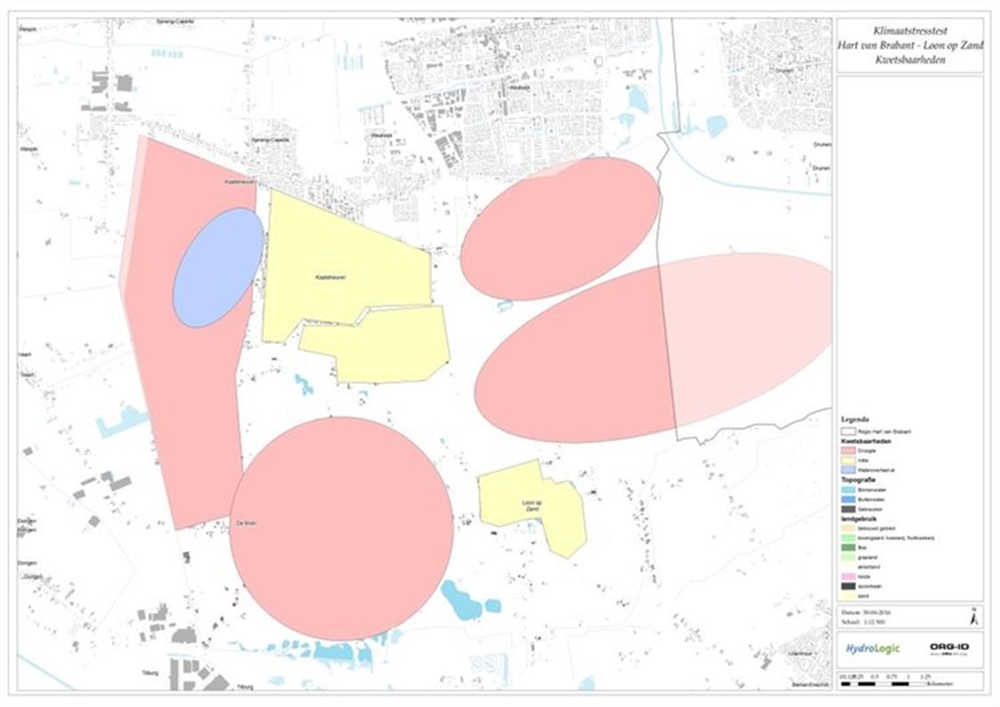
During the climate workshop, we discussed the climate issues. The main comments and vulnerabilities are:
Knowledge issues and development
- Climate change will impact groundwater levels. It would be interesting to examine how the highest average groundwater level and the lowest average groundwater level in the municipality of Loon op Zand will change, and how the loam deposits will influence this process.
- The water collection area on the border between the municipalities of Loon op Zand and Dongen will probably be expanded. How will this affect drought and/or flooding issues in the municipality of Loon op Zand?
- How will heat, e.g., more warm nights, affect the residents? Could people get used to or adjust to the heat?
- What will the heat be like during the daytime?
Climate impact
Flood risk management
- In terms of flood risk management, climate change will only have a minor impact in this municipality. The Loon op Zand urban area will not be affected if the river Meuse overflows. Any residents who will be affected will probably have sufficient time to evacuate. In addition, the risk of Meuse water extending to Loon op Zand is small, because of the flood defence systems located between the river Meuse and the municipality of Loon op Zand.
Flooding
- The municipality is prone to groundwater flooding due to its soil structure. At many locations, loamy layers in the soil hinder the absorption of rainwater.
- The map identifies several locations that have been affected by urban flooding. Some of them, such as the Gasthuislaan, have already been tackled in recent years. A number of streets will be disconnected, which is expected to reduce the risk of flooding.
- An 8-metre difference in height between the eastern and western sections of the Kaatsheuvel urban area causes the water from the urban area to flow west. In addition, some greenhouse market gardeners are draining onto this location. As a result, this area is quite wet. The area is scheduled for development in the future.
Drought
- A fall in the average lowest groundwater level will result in more abstraction bans over a larger area. This could cause problems among the farmers in the municipality of Loon op Zand.
- In the future, the water supply to the north-western section of the municipality can probably no longer be guaranteed. This will cause problems among the farmers located here. The farmers in the south-western section of the municipality are currently not dependent on the district water board for their water supply; consequently, for them, nothing much will change in this respect.
- Nature is quite vulnerable to drought. Several locations comprise peaty soil, which could dry up as a result of falling groundwater levels. The “Drunense Duinen” forest area already involves dry Nature; in this area, drought will have less of an impact.
- North of Kaatsheuvel lies a pool whose water is of poor quality. This water quality might deteriorate as a result of drought.
Heat
- The urban areas of Kaatsheuvel and Loon op Zand feature little greenery. As a result, they are more prone to heat pressure. Heat stress is also an important issue for the Efteling theme park.
- Heat also affects factory farming. Cows produce less milk during prolonged heat spells with more warm nights.
More details on the conclusions and recommendations are provided in the document pertaining to this practical example.
Contact person
Albert Elshof
ORG-ID
06 53 66 18 69
elshof@org-id.org