Climate adaptation in Rhine Estuary-Drechtsteden area – learning from areas outside the dykes
Due to the rise in sea level ensuing from climate change, the risk of urban flooding is increasing. In the Rhine Estuary-Drechtsteden region, several stakeholders have joined forces under the Delta Programme to work on flood risk management. A special feature of this region is that a large section, such as the port of Rotterdam, is located outside the dykes and consequently not protected by the primary flood defence systems. In collaboration with the stakeholders, a strategic adaptation agenda has been drawn up for this area. This agenda is flexible, will develop over time, and sets out actions to ensure the flood protection of the Rhine Estuary-Drechtsteden areas outside the dykes. The underlying principle is that users, residents, and the government share ownership of a flood-proof area.
The current flood risk management policy for the areas outside the dykes is largely based on the principle that users and residents themselves are responsible for taking measures to reduce damage caused by flooding. In the event of new developments, the government will assess the risks and, if need be, set down preconditions to contain such risks. Responsibility for communication regarding the risks is vested with the government.
Climate change raises the question of whether and to what extent responsibility for flood protection can be vested with users and residents of areas outside the dykes, when the sea level rises. Not just on account of their own safety, but also on account of the economic value of the area. The Rhine Estuary-Drechtsteden areas outside the dykes accommodate some 60,000 residents and the port of Rotterdam, which accounts for a significant proportion of the gross national product. A flood could cause major damage to (historic) buildings, port activities, and infrastructure, but also to facilities such as electric power supply and data traffic. Flood risk management outside the dykes thus constitutes a comprehensive social issue in this region. Will there come a time when communication regarding flood risks by the government and individual measures by users and residents will no longer suffice?

Collectively learning from the flood risk management tasking in the pilot areas
In 2014, pilot areas were designated in the sections outside the dykes in the purview of the Rhine Estuary-Drechtsteden Delta Programme. In these pilot areas, the flood risk management tasking has been explored on account of the increasing probability of sea and river flooding. Each area has its own specific character and the taskings differ accordingly. The pilot areas are (see image 2):
- Noordereiland and Kop van Feijenoord in Rotterdam, a mix of residential, shopping, and business areas, some of which (Kop van Feijenoord) are in transition;
- Merwe-Vierhavens in Rotterdam, predominantly business and shopping areas, envisaging a transition to a residential and business district with effect from 2020;
- Botlek and Vondelingenplaat in Rotterdam, industrial port district;
- Historic port district in Dordrecht, highly urbanised, historic city centre with a predominantly residential function.
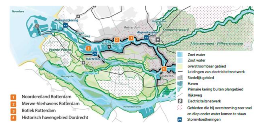
Image: Overview of the region with the pilot areas outside the dykes
In recent years, research has been conducted in these areas in the field of flood risk management. The municipality of Rotterdam and Royal HaskoningDHV have gathered together the parties involved in the pilot area studies to share the insights and lessons. These insights and lessons together constitute the basis for the strategic adaptation agenda for the areas outside the dykes. The six main insights and lessons are listed below.
Lesson no. 1: the main impact of climate change in the area outside the dykes is the increased economic risk.
The flood risk management tasking in the pilot areas shows that the probability of flooding in the area is increasing as a result of climate change. However, on account of the higher elevation of the area, it seems that a flood will cause few or no fatalities. The risk of flooding in the industrial estates causing environmental damage also seems smaller than assumed. Although the probability of flooding is currently small, a flood could cause major economic damage, especially in the port of Rotterdam. Chain effects could even carry its impact far beyond the Dutch border.
Lesson no. 2: users and residents of the areas outside the dykes are not fully aware of flood risks and their own responsibilities.
The risks, particularly those involving economic damage, are increasing. However, the users and residents of areas outside the dykes do not seem to be fully aware of such risks and/or feel little urgency to take measures. Only areas affected by annual waterlogging, such as the quays of the Noordereiland in Rotterdam and the historic port district of Dordrecht, bolster greater awareness. These are the locations at which the municipality and/or the residents and users are already implementing physical measures of their own, and at which the municipality is actively communicating on lines of action in the event of a flood.
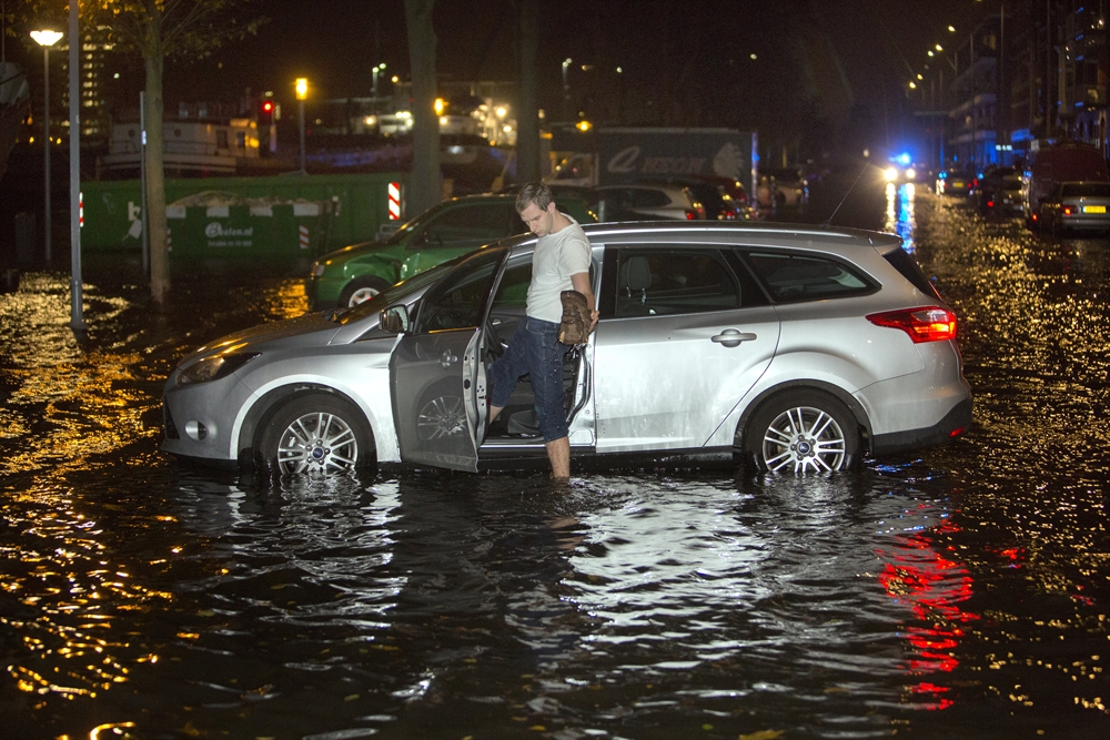 age: wet feet on the Noordereiland, December 2013
The authorities are making an effort to raise awareness of flood risks and potential measures in other elevated areas outside the dykes. These mainly involve the residential and port districts that have been constructed at an elevation in recent decades, which currently ensures their relative safety. Furthermore, many parties are not or are insufficiently aware of the principle of “individual responsibility for flood damage”. In many cases, users and residents of areas outside the dykes assume that the government will provide protection and take measures if such is needed. Or they expect that their insurance will cover flood risks. However, most building and home content insurances will not compensate damage caused by flooding. As yet, insurance companies regard a major flood as too high a business risk.
Lesson no. 3: a “joint fact-finding” process involving all public and private parties will raise awareness and garner support for measures.
Awareness of flood protection and individual responsibilities will increase if the government, businesses, and other users of areas outside the dykes collectively map out flood risks and the impact of flooding. Furthermore, such a joint fact-finding process will boost willingness to develop a collective climate adaptation strategy. In such a strategy, the parties set down the measures that need to be taken at a particular time in order to contain the flood risk. This process requires a tailored approach for each specific area.
Lesson no. 4: a collective climate adaptation strategy is difficult to formulate without a shared perception of the acceptable risk.
The moment at which a risk ceases to be acceptable may define the moment at which a measure is to be taken. A threshold for the development of a collective climate adaptation strategy is that each party holds different views regarding risk acceptance. In the absence of statutory flood protection standards for areas outside the dykes, residents, users, and the government each assess risks differently. In order to develop a collective language, an assessment framework has been set down for the Botlek and Vondelingenplaat pilot areas based on inland “standards” (such as a tolerable individual risk of 1*10-5 per annum) and knowledge of external security.
Despite remaining differences in risk assessment between the parties, the assessment framework has produced an initial picture of the moment at which the flood risk becomes too great. Furthermore, it has raised awareness of the issue and garnered support among the parties involved.
Lesson no. 5: prevention, spatial adaptation, and disaster management as set down in the multi-layer flood risk management concept for areas situated on the land side of dykes hold added value for climate adaptation in areas on the sea side of dykes.
The concept of multi-layer flood risk management has been developed in the purview of the flood protection of areas situated inside the dykes. However, in some cases, combining preventative measures with measures aimed at spatial planning and disaster management appears cumbersome, because preventative measures such as raising a dyke tend to be much more cost-effective. Furthermore, in our country, it is up to the government to provide users and residents of inland areas with a certain degree of flood protection. In areas outside the dykes, responsibility for taking measures to contain flood damage lies, in principle, with users and residents themselves.
The pilot studies conducted in areas outside the dykes have shown that multi-layer flood risk management provides the stakeholders with a comprehensive view of various types of measures, ranging from individual to collective responses to flood risks. A case in point is the intention of the private parties in the Botlek and Vondelingenplaat pilots to elaborate a regional contingency plan: a plan with which businesses arrange a regulated switch-off amongst themselves, in the event that extremely high water should cause problems. The spatial planning and disaster control layers feature expressly in the adaptation strategies for the various pilot areas, alongside preventative measures such as constructing a dyke. Moreover, in most areas outside the dykes, a flood will run a different course compared to an inland flood. Because of the high(er) elevation, the water will rise less rapidly and less high. Consequently, measures in the spatial adaptation and disaster control domains constitute realistic alternatives.
In short, the multi-layer perspective from which the adaptation strategies in the pilot areas have been considered will help to concretize agendas for action at all levels and for all parties.
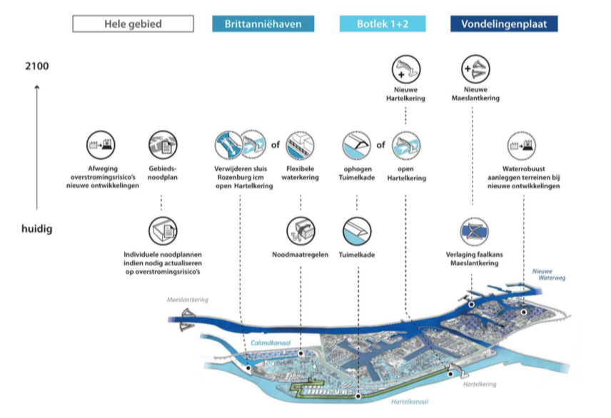 Image: study into promising adaptation strategy for Botlek and Vondelingenplaat, with attention to prevention, spatial planning, and disaster control.
Lesson no. 6: there is no “one size fits all” strategy
An effective adaptation strategy calls for customisation. The above paragraph already has pointed out that joint fact-finding calls for a region-specific substantiation, tailored to the local stakeholders and their interests. The measures also require a customised schedule tailored to each specific area. Spatial adaptation thus opens up the opportunity of adding value and spatial quality to areas under development and/or being restructured. Areas featuring low development dynamics, such as the Dordrecht historic port area with many historic buildings close to the waterside, hold less room for large-scale adaptation or prevention. Local individual measures, communication regarding flood risks, and disaster control seem to offer greater potential here. However, in the light of climate change, in the long run such areas may require reassessment of this strategy and perhaps a more large-scale preventative measure.
Time is also a factor in the customisation of the adaptation strategy. The increase in flood risks, possibly in combination with linkage opportunities created by spatial developments, may call for a switch in measures. Other, more large-scale measures may become more effective in the light of increasing damage, but also in the light of new insights into the pace of climate change.
The strategic adaptation agenda for areas outside the dykes
The pilot studies conducted in the various areas outside the dykes have demonstrated the added value of a joint approach by stakeholders from the public and private domains to substantiate flood risk management in the areas located outside the dykes. This requires commitment on the part of the stakeholders from the very start, in order to bolster shared ownership of flood protection.
That is why the municipalities concerned, the province, the district water board, the Rotterdam Port Authority, Rijkswaterstaat, utility companies, and the private sector have been involved in the formulation of the strategic adaptation agenda. They have used the lessons learned in the four pilot areas to formulate actions aimed at securing the short-term and long-term flood protection of the Rhine Estuary-Drechtsteden areas outside the dykes. Such actions constitute the core of the strategic adaptation agenda for the areas outside the dykes; they range from the formulation of an adaptation strategy for a sub-area and embedding flood risk management outside the dykes in environmental visions and environmental plans to concrete measures.
The strategic adaptation agenda aims to concretize a collective ambition, viz., protecting the areas outside the dykes from flooding, into actions for all the parties, to link activities undertaken by various actors (integrality), and to prioritise measures. Collaboration and sharing knowledge play an important part in this respect. The current interests, responsibilities, and roles constitute the point of departure for the exploration of future actions and for assigning such actions to the various players. The basic ideas of the agenda boil down to:
- more efficient substantiation and optimisation of the current governance;
- area-specific adaptation strategies, coordinated with the regional Preferential Strategy of the Rhine Estuary-Drechtsteden Delta Programme.
Optimisation of current governance
A flood-proof, liveable, and economically strong area outside the dykes requires choices, shared governance, and collective action focused on the social interest of such areas. However, the governance of (developments in) areas outside the dykes is not a simple matter, as is reflected in Figure 5, considering the existing division of tasks among stakeholders. As in inland areas, all the governments, users, and residents in areas outside the dykes have roles and responsibilities that have a bearing on flood risk management, liveability, and the economy. Ergo, responsibility does not lie solely with “the resident or user”, which seems to be the point of departure in the policy that is currently pursued. Public parties also have an interest in flood-proof and liveable areas outside the dykes and bear responsibility for such areas in several fields.
Climate change is challenging stakeholders to review the governance of flood risk management. The issue of who will foot the bill for the protection of existing areas illustrates a potential optimisation of current governance. If raised embankments in existing areas would seem effective, such construction could be arranged via existing policy on foreland flood defences. In such cases, optimisation mainly involves securing management and maintenance funding, for example, through levying taxes on the residents of areas outside the dykes (certain areas qualify for a reduction in land draining rates). This clearly calls for collaboration and agreements between the parties.
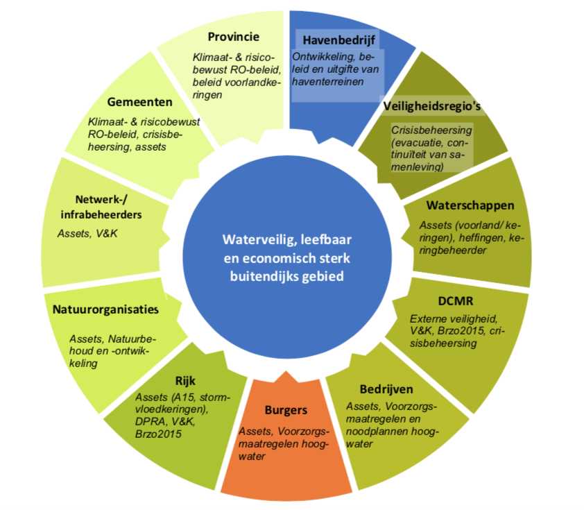
Image: overview of parties with interests and responsibilities in areas outside the dykes (DPRA = Delta Plan on Spatial Adaptation, RO = Spatial Development, V&K = Vital & Vulnerable, Brzo = Decree on Major Accident Hazards)
Area-specific adaptation strategies
An important objective of the agenda is to ensure that all the municipalities in the region are aware of the risks and opportunities involved in flood risk management in their areas outside the dykes, and to encourage such municipalities to set down their ambitions for these areas. By 2020, it must be clear for each area in this region that is situated outside the dykes which strategy will be pursued. This is why, in the near future (2020), adaptation strategies for each sub-area in the entire Rhine Estuary-Drechtsteden region must be elaborated on the basis of the strategic adaptation agenda. For several sub-areas, this strategy will already be translated into specific implementation actions that are properly substantiated in terms of organisation and funding. However, the actual time of realisation of all the intended measures in the entire area also depends on the risk assessment conducted. In the light of the pace of climate change, this will need regular evaluation. Regular reflection is also needed in order to respond to changes in the environment, regulations, or the Delta Programme Preferential Strategy for the Rhine Estuary-Drechtsteden region. In addition, this will enable us to monitor whether scheduled actions will suffice to achieve the ambition. This means that the agenda will develop further over time.
Hand in hand towards a flood-proof future outside the dykes
Public and private parties will need to join forces to control the risk and impact of flooding in the Rhine Estuary-Drechtsteden areas outside the dykes. The reflection on flood risk management in the pilot areas and on the subsequent steps as identified in the adaptation agenda has created awareness of the urgency to collaborate on securing flood protection in the areas outside the dykes. Furthermore, it has bolstered commitment to take action. This marks an important step in collectively safeguarding the flood protection of the Rhine Estuary-Drechtsteden areas outside the dykes.
Contact person
Corjan Gebraad
Gemeente Rotterdam
cj.gebraad@Rotterdam.nl
Source: H2O, june 2018