Impact project: water risks in spatial developments and assets
Specific standards and design guidelines are in place with respect to sewer systems, drainage canals, and flood defence systems. Yet some risk of waterlogging and urban flooding remains. Governments and authorities in charge of such objects must make choices regarding such risks: is a risk acceptable or are some measures required? And if so, what measures? These are complex questions. How do you make such comparative assessments?
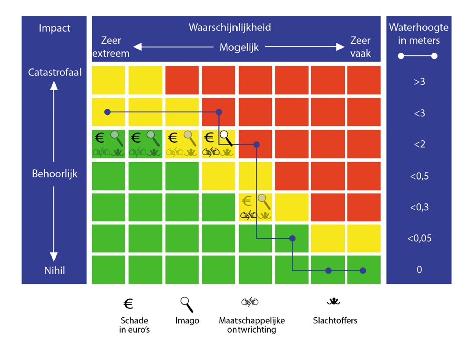
In order to facilitate the assessment of water risks, parties involved in the Climate Adaptation City Deal have collectively developed an assessment framework based on the “Water Risk Diagrams” method. This method enables mapping out all the water risks for specific locations or objects. This helps governments and managing authorities in their assessment of the risks.
Goal of the project
By employing this method, the Climate Adaptation City Deal parties hope to accomplish the following:
- Governments and managing authorities will not hesitate to implement measures, because they have been able to properly assess the risks;
- Governments and managing authorities will no longer focus only on the most extreme flooding scenarios. This method encourages them to factor in all types of water-related risks, including risks that occur more frequently.
Step-by-step plan
This step-by-step plan assists managing authorities and government bodies in following the method independently:
- Select the object for which you will be using the method. For example, select a particular object for which a risk has been identified during a risk dialogue. Set down the xy coordinates of the object.
- Draw up a water risk profile. To this end, you must map out the exceedance frequency of the local flooding depth for the location, based on a representative set of various potential events. You can use your own scenarios for this purpose, and open data from the National Water and Flooding Information System (LIWO).
- Which assessment framework will you be using: the water risk diagram or your own company value matrix? You can add or remove impact parameters and set down the level of detail by adding categories.
- Fill in the water risk diagram or the company value matrix. This step will demonstrate the impact, based on a quantitative or qualitative assessment. The impact is not measured in exact values, but rather in categories (such as moderate or serious effects).
- Make your final assessments and take decisions. Map out the effects of measures and choose which measures you will or will not take. In doing so, consider explicitly whether the combination of “impact and probability” is acceptable.
Lessons to be learned
- The method helps to determine for which objects such measures are imperative and for which they are not. The method encourages users to think: what is the relation between the object and its function? Is it an important link?
- There is some tension between the management of an individual object and the object’s function in a wider network or in society. Objects and networks are interdependent. Furthermore, the societal perspective of an object differs from its management’s perspective. They assign different interests to the object.
- Because the method helps to concretise water risks and considerations, it contributes to expediting risk dialogues in the climate adaptation process.
- The method can also be employed in more comprehensive environmental assessments under the Environment Act.
Contact person
Rob Koeze
Waternet
rob.koeze@waternet.nl
06 - 5253 4645