How is precipitation changing?
As a result of climate change, precipitation volumes are increasing, as is the frequency of torrential rain. But how much wetter will it be? And why is precipitation increasing?
How has precipitation changed over the past century?
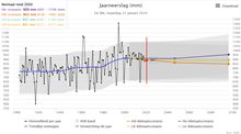
Annual precipitation in the Netherlands increased by 26% between 1910 and 2022. Winters have become particularly wetter, but summer precipitation has also increased. The number of precipitation days has hardly increased, if at all. This means that precipitation has predominantly become heavier, e.g., during torrential summer rain. Annual precipitation volumes have hardly increased since 2000, as autumn and spring precipitation have decreased since then. However, extreme precipitation events have increased further. The Environmental Data Compendium shows that the number of days with more than 50 millimetres has increased by 85% since 1951. At the same time, the image below from the Climate Dashboard shows that annual precipitation can vary greatly: the years 2003 and 2018 were very dry, for example.
Why is precipitation increasing?
Precipitation volumes are primarily increasing as a result of global warming: warm air can hold more moisture. For each degree of warming, the maximum air moisture holding capacity will rise by approx. 7 per cent. In addition, other changes are also contributing to the increase in future precipitation volumes, such as wind direction and cloud processes. Thus, precipitation volumes may increase by more than 7 per cent for each degree of warming. This applies to, e.g., prolonged and large-scale winter precipitation during westerly winds. Inner cloud processes also play a key part in small-scale severe downpours. For example, more heat is released when clouds form droplets in high-moisture air. Consequently, in the event of severe downpours, precipitation volumes may even increase two or three times more sharply than by 7 per cent for each degree of warming. More details are provided in the KNMI explanation of extreme precipitation.
What is extreme precipitation?
In the Netherlands, a downpour involving more than 25 millimetres of precipitation in one hour is referred to as torrential rain. A day that sees more than 50 millimetres of precipitation is called a “heavy precipitation day”. Volumes in excess of 50 millimetres of precipitation in an hour and 100 millimetres in a day are considered extreme precipitation events in terms of the Dutch climate. Such events occur approx. once every 100 years on a particular location in the Netherlands. A description such as “once every 100 years” may be misleading: it may give the impression that such downpours occur very rarely. What is meant, however, is that such an extreme downpour will occur once every 100 years at that particular location. Such downpours occur almost every year somewhere in the Netherlands. Want to know more about extreme precipitation? View the KNMI website for a detailed explanation.
How will precipitation change in the future?
The KNMI'23 scenarios show that winters will become wetter and summers drier in the future. But the extent is uncertain. This is because the Netherlands is in a wide transition area between a drier Mediterranean and a wetter Scandinavia. Therefore, two scenarios are possible: A wet scenario in which the first effect dominates, with winters becoming very wet and summers slightly dry. And a dry scenario in which winters become slightly wet and summers dry out strongly. All this results in little change in annual precipitation amounts in the future (between -3% and +8% in 2100), with winters becoming wetter and extreme summer downpours increasing further in both scenarios.
The climate scenario ‘Waterlogging' of the Climate Impact Atlas shows how precipitation may change in the future. This scenario is based on the KNMI'23 scenarios. You click on the waterlogging icon and then you can see how precipitation may change for the current climate and the four different future scenarios. You can do this using a variety of indicators, such as annual precipitation, hourly or daily precipitation once every 10 years, or the number of days when precipitation exceeds 25 millimetres.
Do you want to know how much the water level at a certain location may rise due to heavy precipitation? Or how the likelyhood of waterlogging in your area will increase due to climate change? Then go to the waterlogging maps in the Climate Impact Atlas.