Drought and greenery guidelines with discussion maps
A research consortium operating within the NKWK Climate-proof Cities focus area has developed guidelines and six discussion maps intended to help municipalities to drought-proof greenery in urban areas, factoring in the impact on the water balance. In addition, the guidelines explain how to embed such measures in the development or redevelopment processes of public spaces.
For whom?
The guidelines and the six discussion maps have been developed for municipal staff, in particular municipal greenery departments.
How can the guidelines be used?
The guidelines comprise an overview of the process involved in the development or redevelopment of public areas: from initiative to maintenance. This overview shows greenery staff the process stages at which consultation with other disciplines within the physical domain would be advisable. This facilitates discussion with the other municipal departments and other parties, and ensures that the wishes and conditions of various domains are taken into consideration in good time. Six discussion maps have been developed in the purview of the consultations. The overview also reflects important pitfalls in the management and monitoring stage. This is a key stage for the improvement or maintenance of optimum growth locations for greenery. In addition, the guidelines help greenery staff to make drought-proof choices in day-to-day practice, and to enhance the resilience of public areas.
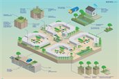
How can the discussion maps be used?
The discussion maps visualise a perspective of options for drought-proofing a neighbourhood. A total of six discussion maps have been developed: for cauliflower neighbourhoods, older neighbourhoods, and suburban expansion (Vinex) neighbourhoods, and for low-lying and elevated parts of the Netherlands.
Who has developed the guidelines and discussion maps?
The guidelines and discussion maps have been developed by Sweco, TAUW, Deltares, Arcadis, Royal HaskoningDHV, and Amsterdam University of Applied Sciences.
Date of publication
15 March 2023